Jacksonville Senior Games tennis event rescheduled due to expected inclement weather from Tropical Storm Imelda
Read full article: Jacksonville Senior Games tennis event rescheduled due to expected inclement weather from Tropical Storm ImeldaDue to the inclement weather forecasted for Monday, the Tennis Event scheduled as part of the City of Jacksonville Senior Games has been rescheduled to Monday, Oct. 6 at 9 a.m.
Waves roll in from Atlantic as Humberto, other disturbance, gets closer to Florida, Georgia
Read full article: Waves roll in from Atlantic as Humberto, other disturbance, gets closer to Florida, GeorgiaWaves are rolling in from the Atlantic as Humberto and another disturbance get closer to Florida and Georgia.
Breezy with a few showers this evening, cool start tomorrow
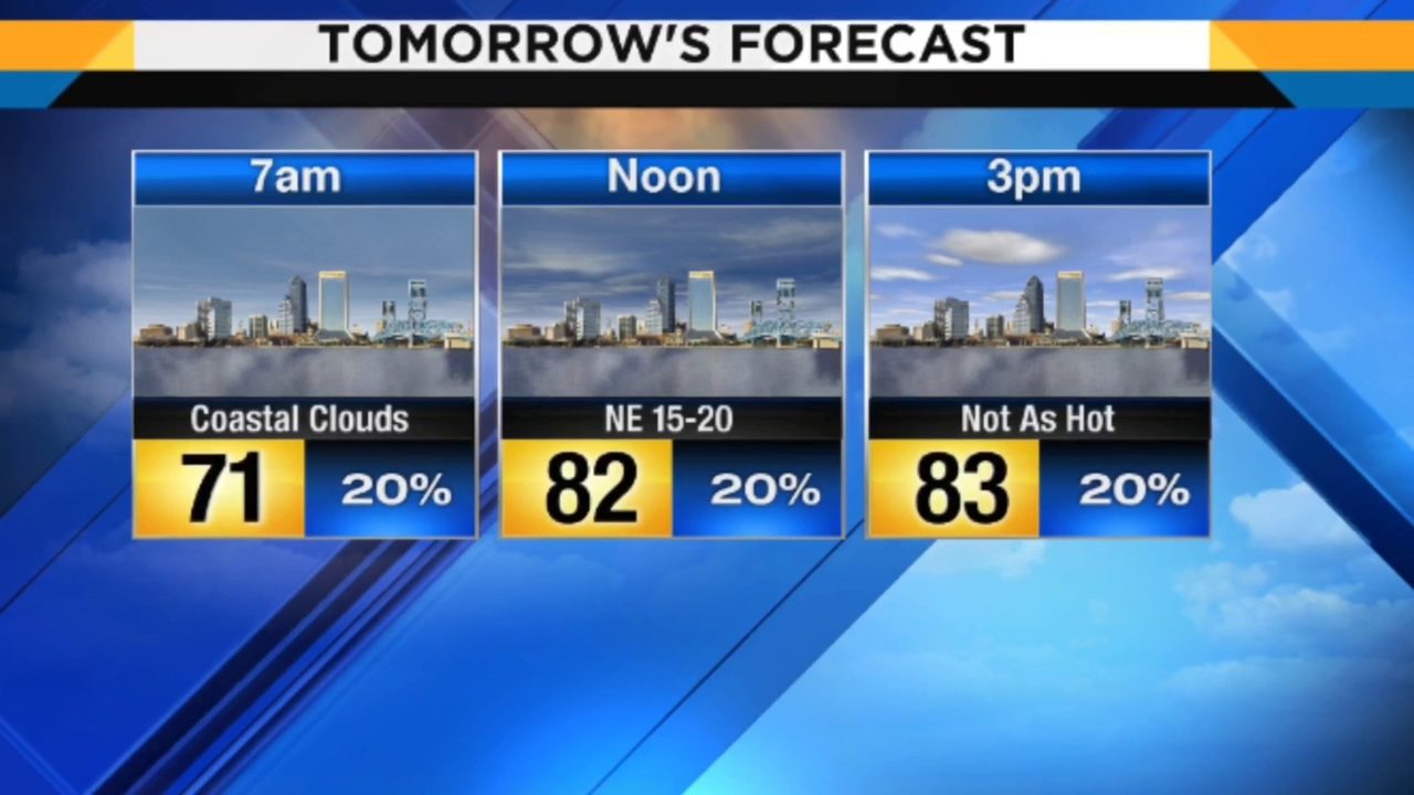
Read full article: Breezy with a few showers this evening, cool start tomorrowA few rounds of coastal showers were pushed onshore by our gusty winds. As we head through the evening hours, a round or two of showers is still poised to be pushed onshore as we head through the evening hours. We will see a few showers pushed onshore by the winds, making for 30% chances for rain. Expect mostly sunny skies, onshore winds out of the east between 12-17 mph, and slightly cooler temperatures. We will wake up in t he mid to upper 60s and warm up into the mid 80s.
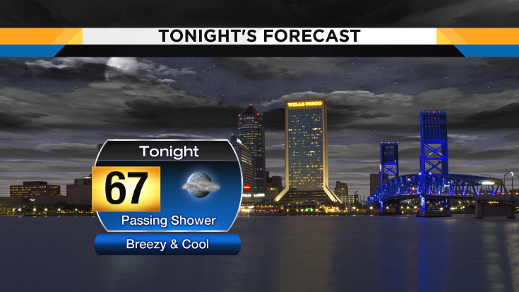
Passing showers this afternoon, breezy this evening
Read full article: Passing showers this afternoon, breezy this eveningYou will see building northeasterly winds behind the front, making for a breezy and comfortable evening, with overnight lows getting down into the upper 60s and low 70s. You have a 20% chance to get swiped by a coastal shower pushing onshore. Gusty onshore winds will define the forecast, bringing clouds onshore and an isolated coastal shower, keeping us cooler, and prompting minor flooding during times of high tide. A high risk for rip currents and minor coastal flooding during time of high tide continues thanks to the onshore winds. We have a 20% chance for an isolated coastal shower to wander onshore.

Category 3 Humberto may swipe Bermuda Wednesday
Read full article: Category 3 Humberto may swipe Bermuda WednesdayHumberto, a sprawling Category 3 storm, is packing sustained winds of 115 mph as it pushes east-northeast about 285 miles west of Bermuda, the National Hurricane Center said Wednesday at 5 a.m. Two to 4 inches of rain, dangerous waves along south-facing beaches and a storm surge of 1 to 3 feet also are expected, the hurricane center said. And Tropical Storm Jerry, still far east of the Leeward Islands, could strengthen into a hurricane by week's end. Humberto could strengthen as it passes Wednesday into Thursday morning less than 100 miles to the island's north, Jones and Garrett said. "Weather should begin to deteriorate in Bermuda later today," the hurricane center said early Wednesday.

Adventures in Gods Creation collecting donations to Bahamas
Read full article: Adventures in Gods Creation collecting donations to BahamasJACKSONVILLE, Fla. - Help is returning to the Bahamas after relief efforts were temporarily suspended ahead of Humberto. To help, many organizations including Adventures in Gods Creation, are collecting donations and raising money. Adventures in Gods Creation in Jacksonville Beach is working with other relief teams to collect donations and get supplies to some of the hardest-hit areas in the Bahamas. By ship, the American Red Cross sent supplies from its warehouses. It's really important that the individuals get some kind of dollars that they can start purchasing things again," said Christian Smith with the American Red Cross.

TS Humberto forecast to be hurricane Sunday
Read full article: TS Humberto forecast to be hurricane SundayCNN Weather(CNN) - The Bahamas missed the brunt of Tropical Storm Humberto, which is expected to become a hurricane Sunday. Humberto is moving away from the Bahamas and is about 180 miles (290 km) northwest of Great Abaco Island and 165 miles (270 km) east of Cape Canaveral, Florida, according to the National Hurricane Center. The storm is slowly strengthening and is expected to become a hurricane on Sunday, said CNN Meteorologist Derek Van Dam. The storm is forecast to continue moving away from the Bahamas and remain well offshore of Florida's east coast through Wednesday, the center said. The islands did get some rain, Van Dam said, but did not get Humberto's full impact.
Tropical storm Humberto gets closer
Read full article: Tropical storm Humberto gets closerA tropical depression is poised to hit the same northern Bahamian islands that Hurricane Dorian ravaged earlier this month -- and it may be a tropical storm when it does. (CNN) - Humberto is now a tropical storm barreling its way through the Atlantic and threatening the same northwestern Bahamas islands ravaged by Hurricane Dorian nearly two weeks ago. A tropical storm warning was in effect for the northwestern Bahamas, excluding Andros Island, the center said. "Since there is increasing confidence that the storm will remain well offshore of the coast of Florida, the tropical storm watch for that area has been discontinued," the center said. Swells generated by the tropical storm are expected to increase and affect the coasts of central Florida to South Carolina through early next week.
Weekend forecast dries out a bit with track shifts in the Tropics
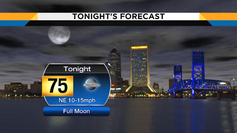
Read full article: Weekend forecast dries out a bit with track shifts in the TropicsEvening temperatures will sink down through the 80s slowly, with east-northeasterly winds between 10-15 mph overnight. Saturday's forecast has dried out a bit thanks to Potential Tropical Cyclone 9's track shift to the east. Expect partly cloudy skies to start out with and windy conditions. Expect mostly cloudy skies and good chances to get rained on. By the mid day rain chances are more isolated and skies turn partly cloudy.

John Gaughan: Watch system in Caribbean closely as a lot could change
Read full article: John Gaughan: Watch system in Caribbean closely as a lot could changeJACKSONVILLE, Fla. - As you are aware, we are closely watching 95L, an area of low pressure over the Southern Bahamas. Thursday mornings visible satellite images dont reveal anything too interesting, suggesting that if it does develop, it wont be until Friday. One model cranks this up into Humberto and tracks it up (offshore) the East Coast of Florida this weekend, becoming a hurricane by Monday. The more preferable forecast model for our area shows a weak tropical storm (still Humberto) cutting across the state from Fort Lauderdale to Tallahassee. These events have a high possibility:Humberto forms on Friday eveningTropical Storm Watches and maybe Warnings will be placed along our coast on Saturday and/or Sunday.
John Gaughan: Watch system in Caribbean closely as a lot could change
Read full article: John Gaughan: Watch system in Caribbean closely as a lot could changeJACKSONVILLE, Fla. - As you are aware, we are closely watching 95L, an area of low pressure over the Southern Bahamas. Thursday morning's visible satellite images don't reveal anything too interesting, suggesting that if it does develop, it won't be until Friday. One model cranks this up into Humberto and tracks it up (offshore) the East Coast of Florida this weekend, becoming a hurricane by Monday. The more preferable forecast model for our area shows a weak tropical storm (still Humberto) cutting across the state from Fort Lauderdale to Tallahassee. These events have a high possibility:Humberto forms on Friday eveningTropical Storm Watches and maybe Warnings will be placed along our coast on Saturday and/or Sunday.

Increasing chances for Humberto this weekend
Read full article: Increasing chances for Humberto this weekendAfter what the Bahamas just endured with Hurricane Dorian, all eyes are keeping watch on what the National Hurricane Center is saying about a new area of disturbance that could become "Humberto." While remaining weak, this would mean wet conditions for nearly the entire area over the weekend. This graphic shows what the GFS model predicts for this system over the weekend. If this were to occur we would see even less rain and wind than what we saw with Dorian. This disturbance will bring heavy rainfall and gusty winds across portions of the Bahamas through Friday, especially in portions of the northwestern Bahamas affected by Hurricane Dorian.
John Gaughan: Watch system in Caribbean closely, a lot could change
Read full article: John Gaughan: Watch system in Caribbean closely, a lot could changeJACKSONVILLE, Fla. - As you are aware, we are closely watching 95L, an area of low pressure over the Southern Bahamas. Thursday morning's visible satellite images don't reveal anything too interesting, suggesting that if it does develop, it won't be until Friday. The more preferable forecast model for our area shows a weak tropical storm (still Humberto) cutting across the state from Fort Lauderdale to Tallahassee. Impact on a tropical damage scale of 1-10 would be a 0.5 -- yes, zero point five. These events have a high possibility:Humberto forms on Friday eveningTropical Storm Watches and maybe Warnings will be placed along our coast on Saturday and/or Sunday.